Territories in SiteZeus allow you to define boundaries so its easy to classify geographic areas for the purposes of territory management.
- Standard sets
- Analyzing sets and shapes
- Polygon shape tools
- Import / export territories
- Restricted territories
Using territories
To access Territories, press the Territories button on the map toolbar. It will launch a panel with Standard Sets, and if you're subscribed to custom shapes, My Sets and ability to Import/Export.
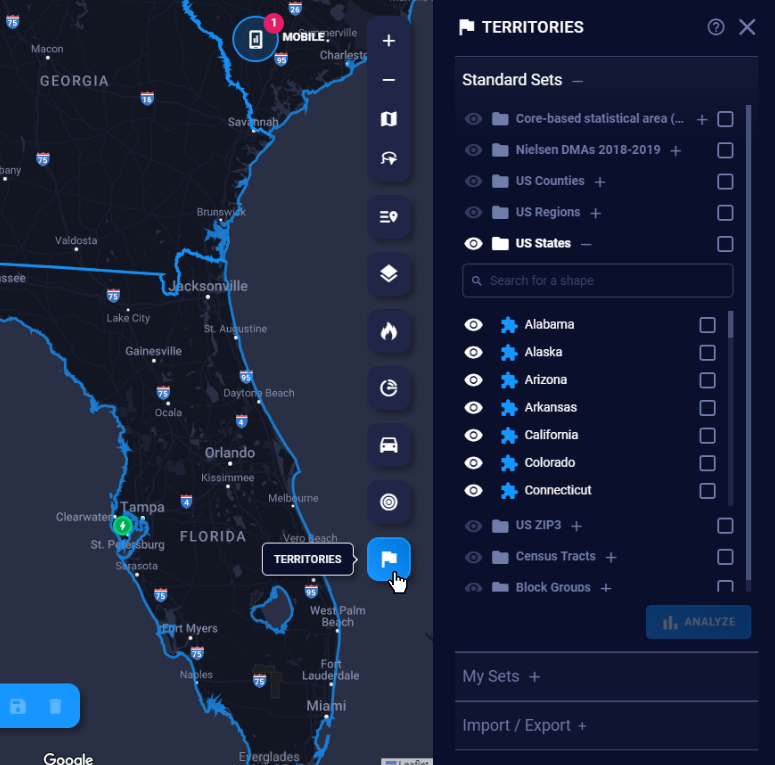
Standard Sets
You can visualize and analyze popular sets of shapes.
- Core-Based Statistical Areas (CBSAs): U.S. geographic areas defined by the Office of Management and Budget that consist of one or more counties (or equivalents) anchored by an urban center of at least 10,000 people
- Nielsen Designated Market Areas (DMAs): The geographic areas in the United States in which local television viewing is measured by The Nielsen Company
- U.S. regions: Census Bureau shapes dividing the country into the East, Midwest, South, and West
- U.S. states: Shapes for the 50 U.S. States and the District of Columbia
- U.S. counties: Shapes for all counties in the United States
- ZIP3: Areas based on the first three (or sometimes four) digits of U.S. ZIP codes
- Census tracts: Census administrative districts used in collating census data within a county
- Block groups: Statistical divisions of the census tract areas and the smallest geographical division available
Generating census tracts and block groups
For a more granular analysis, use the new census tracts and block groups polygons.
Note: Due to their high volume, these polygons must be loaded within a larger boundary to maintain optimal performance.
- Click census tracts to expand the set, then click the Show counties link to see all counties displayed on the map.
- Select the counties you want to generate census tracts within by clicking the shapes on the map or using the checkbox next to that county in the list. After you’ve made your selections, click Generate.
- The census tracts will appear inside those counties. The county set will now be hidden, and the census tracts set will be visible. You will also see census tracts appear in the list, where you can toggle them on and off.
- You can now select individual tracts for demographic analysis and more.
To include additional census tracts, click Show counties again and select more, then use the link to toggle between counties and census tracts to add the ones you need. Click Clear all to delete unwanted shapes.
Polygon Shape Tools
To learn more about how to manage/draw your own custom sets, share them with more of your team, share notes about shapes, and analyze those shapes see Polygon Shape Tools
Import / Export Territories
Import
Import your own custom territories into SiteZeus to view or customize them.
To use the Importer,
- Turn on Territories
- Press Import / Export
- Choose a set to import to or create a new set.
- You can choose to add your imported shapes onto a set or replace the whole set.
- You can import two types of files: GeoJSON or Shapefile.
- GeoJSON - This file will have to have a .geojson file extension.
Download a sample - Shapefile - There are two files required for this type. They will both have to be uploaded at the same time.
- A file with the .shp extension
Download a sample - A file with the .dbf extension
Download a sample
- A file with the .shp extension
- GeoJSON - This file will have to have a .geojson file extension.
- Press Import to begin importing your valid file type.
- If there is a problem with the upload or import, you will receive an alert letting you download the errors.
Tip: For all three of these file types, you will need an external application to edit them. QGIS or Geoman editor are a couple free options.
Export
To export shapes that you have previously imported as sets into the system or that you have drawn as new shapes within the platform:
- Turn on Territories
- Select Import/Export
- Select Export
- Choose a set from the list that you wish to Export
- Select the shape format that you wish to export it as
- Wait for the download to generate and then click the download option in the popup to access the files
This is a legacy feature of SiteZeus, and is located in a different area of the platform. It can be found in Manage Account > Territories